<div class="ubbcode-block"><div class="ubbcode-header">Originally Posted By: Milo Man*</div><div class="ubbcode-body">Looks like the course has shifted a little to the south. Maybe it will just brush JA. [img]/forums/images/%%GRAEMLIN_URL%%/70384-praying.gif[/img] </div></div>
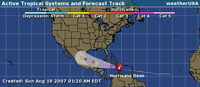
bwoy, dis 2am shot no mek it look like it a go miss wi atall atall..is like u can barely see di island unda di bright fushia spot which indicates winds at 131-155
<div class="ubbcode-block"><div class="ubbcode-header">Originally Posted By: evanovitch</div><div class="ubbcode-body"><div class="ubbcode-block"><div class="ubbcode-header">Originally Posted By: Milo Man*</div><div class="ubbcode-body">Looks like the course has shifted a little to the south. Maybe it will just brush JA. [img]/forums/images/%%GRAEMLIN_URL%%/70384-praying.gif[/img] </div></div>
bwoy, dis 2am shot no mek it look like it a go miss wi atall atall..is like u can barely see di island unda di bright fushia spot which indicates winds at 131-155
</div></div>It is unlikely to hit like direct hit and increase in intensity. Any direct contact with land uaually result in dramatic reduction in intebsity especially mountainous terraine. and me sure that Jamaica no level.
000
WTNT34 KNHC 190550
TCPAT4
BULLETIN HURRICANE DEAN INTERMEDIATE ADVISORY NUMBER 24A
NWS TPC/NATIONAL HURRICANE CENTER MIAMI FL AL042007
200 AM AST SUN AUG 19 2007
...DEAN HEADING TOWARD JAMAICA...
A HURRICANE WARNING REMAINS IN EFFECT FOR THE SOUTHWESTERN PENINSULA
OF HAITI FROM THE HAITI-DOMINICAN REPUBLIC BORDER TO
PORT-AU-PRINCE. A HURRICANE WARNING IS ALSO IN EFFECT FOR JAMAICA
AND THE CAYMAN ISLANDS.
A HURRICANE WARNING MEANS THAT HURRICANE CONDITIONS ARE EXPECTED
WITHIN THE WARNING AREA WITHIN THE NEXT 24 HOURS. PREPARATIONS TO
PROTECT LIFE AND PROPERTY SHOULD BE RUSHED TO COMPLETION.
AT 2 AM AST...0600 UTC...THE GOVERNMENT OF THE DOMINICAN REPUBLIC
HAS CHANGED THE HURRICANE WARNING TO A TROPICAL STORM WARNING FROM
BARAHONA TO THE SOUTHERN HAITI-DOMINICAN REPUBLIC BORDER...AND HAS
DISCONTINUED THE TROPICAL STORM WARNING FROM EAST OF CABO CAUCEDO
TO CABO ENGANO. A TROPICAL STORM WARNING IS IN EFFECT FROM CABO
CAUCEDO WESTWARD TO THE SOUTHERN HAITI-DOMINICAN REPUBLIC BORDER.
A TROPICAL STORM WARNING IS IN EFFECT FOR COAST OF HAITI NORTH OF
PORT-AU-PRINCE TO THE NORTHERN HAITI-DOMINICAN REPUBLIC BORDER. A TROPICAL STORM WARNING IS ALSO IN EFFECT FOR PORTIONS OF EASTERN
CUBA...FROM THE PROVINCE OF CAMAGUEY EASTWARD TO THE PROVINCE OF
GUANTANAMO. A TROPICAL STORM WARNING MEANS THAT TROPICAL STORM
CONDITIONS ARE EXPECTED WITHIN THE WARNING AREA WITHIN THE NEXT 24
HOURS.
A TROPICAL STORM WATCH IS IN EFFECT FOR PORTIONS OF CENTRAL
CUBA...FOR THE PROVINCES OF CIEGO DE AVILA...SANCTI SPIRITUS...
CIENFUEGOS...MATANZAS...AND ISLA DE LA JUVENTUD. A TROPICAL STORM
WATCH MEANS THAT TROPICAL STORM CONDITIONS ARE POSSIBLE WITHIN THE
WATCH AREA...GENERALLY WITHIN 36 HOURS.
INTERESTS ELSEWHERE IN THE WESTERN CARIBBEAN...INCLUDING WESTERN
CUBA AND THE YUCATAN PENINSULA...SHOULD CLOSELY MONITOR THE
PROGRESS OF DEAN.
FOR STORM INFORMATION SPECIFIC TO YOUR AREA...PLEASE MONITOR
PRODUCTS ISSUED BY YOUR LOCAL WEATHER OFFICE.
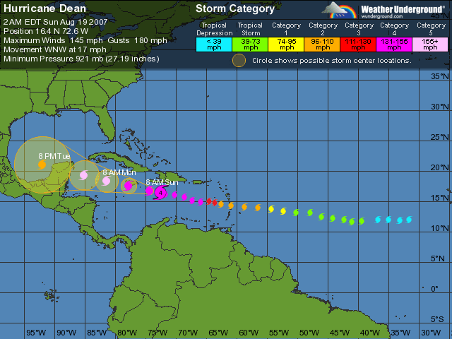
AT 200 AM AST...0600Z...THE EYE OF HURRICANE DEAN WAS LOCATED
NEAR LATITUDE 16.4 NORTH...LONGITUDE 72.6 WEST OR ABOUT 295 MILES...
480 KM...EAST-SOUTHEAST OF KINGSTON JAMAICA AND ABOUT 155 MILES...
245 KM...SOUTH OF PORT AU PRINCE HAITI.
DEAN IS MOVING TOWARD THE WEST-NORTHWEST NEAR 17 MPH...28
KM/HR...AND A WEST-NORTHWESTWARD OR WESTWARD MOTION IS EXPECTED
DURING THE NEXT 24 HOURS. ON THIS TRACK...THE CORE OF THE
HURRICANE WILL PASS JUST SOUTH OF THE SOUTHERN COAST OF HAITI OVER
THE NEXT SEVERAL HOURS AND WILL BE NEAR JAMAICA LATER TODAY.
MAXIMUM SUSTAINED WINDS ARE NEAR 145 MPH...230 KM/HR...WITH HIGHER
GUSTS. DEAN IS AN EXTREMELY DANGEROUS CATEGORY FOUR HURRICANE ON
THE SAFFIR-SIMPSON HURRICANE SCALE. SOME FLUCTUATIONS IN INTENSITY
ARE POSSIBLE DURING THE NEXT 24 HOURS.
HURRICANE FORCE WINDS EXTEND OUTWARD UP TO 60 MILES...95 KM...FROM
THE CENTER...AND TROPICAL STORM FORCE WINDS EXTEND OUTWARD UP TO 205
MILES...335 KM.
AN AIR FORCE HURRICANE HUNTER PLANE RECENTLY MEASURED A MINIMUM
CENTRAL PRESSURE OF 921 MB...27.20 INCHES.
COASTAL STORM SURGE FLOODING OF 7 TO 9 FEET ABOVE NORMAL TIDE
LEVELS...ALONG WITH LARGE AND DANGEROUS BATTERING WAVES...IS
POSSIBLE NEAR THE CENTER OF DEAN WITHIN THE HURRICANE WARNING AREA.
STORM TOTAL RAINFALL AMOUNTS OF 5 TO 10 INCHES CAN BE EXPECTED OVER
JAMAICA...WITH MAXIMUM AMOUNTS OF UP TO 20 INCHES. AMOUNTS
OF 4 TO 6 INCHES ARE POSSIBLE OVER SOUTHERN HISPANIOLA WITH MAXIMUM
TOTALS OF 10 INCHES. THE REMAINDER OF HISPANIOLA AND EASTERN CUBA
COULD RECEIVE 2 TO 4 INCHES OF RAIN...WITH MAXIMUM AMOUNTS UP TO 7
INCHES. THESE RAINS COULD CAUSE LIFE-THREATENING FLASH FLOODS AND
MUDSLIDES.
REPEATING THE 200 AM AST POSITION...16.4 N...72.6 W. MOVEMENT
TOWARD...WEST-NORTHWEST NEAR 17 MPH. MAXIMUM SUSTAINED WINDS...145
MPH. MINIMUM CENTRAL PRESSURE...921 MB.
THE NEXT ADVISORY WILL BE ISSUED BY THE NATIONAL HURRICANE CENTER AT
500 AM AST.
If you take note you will see that they are predicting a movement between west northwest and westward. In other words it is moving westward,but they would rather it to move west northwest. since the latter will attract greater viewership since more eyes means more earnings.
It is all in the $$
EDITORIAL - On hurricane watch
published: Sunday | August 19, 2007
As we went to press last night, there remained every expectation that Jamaica would suffer a devastating blow from Hurricane Dean. Whichever path it takes today, whether a direct hit on the island as forecast by meteorologists, or veering slightly to the north or south, the country is still likely to suffer significant damage to its physical infrastructure. Our experience with recent heavy rains indicates that many of the road structures are not able to withstand sustained rain erosion for several hours, let alone two days. The full impact on individuals' lives and the country as a whole will take some time to assess.
Some of the damage will be mitigated by the preparations that were done. Yet preparations have to be done at the individual and national level. There are some things that householders can do, and others that only a government can. The cleaning of drains and gullies, for example, is the responsibility of central and local government agencies. Individuals, however, set themselves up to experience untold suffering and damage when they dump rubbish and other debris into waterways. Thankfully, since our experience with Hurricane Gilbert in September 1988, we have managed to keep most aspects of the island's emergency response agencies sufficiently equipped to allow them to render aid as required. Yet, even in the best of planned scenarios, there will be situations that put the capabilities of these agencies to the test.
Many people were already under pressure to make adequate preparations, given their financial challenges. The state apparatus will also be under strain, but hopefully, we will riseto the challenges to help ourselves to recover as quickly as possible.
The immediate post-hurricane period will also throw up different challenges. There will be complaints of slow or inadequate response and of areas being inaccessible. Wit stress, there will be even more manifestations of short temper and anger. We urge all our fellow citizens to exercise due care, caution and patience in this time of national challenge.
With this hurricane coming at th of a general election campaign, the temptation to grandstanding, points scoring and exploiting the misery of people for political gain will be hard to resist among the more rabidly partisan among us. We appeal to our politicians to let good sense prevail and to do what they can for the national good, simply because it is the right and decent thing to do.
We have demonstrated in the past that we are a resilient people and that in times of crises we can join together to accomplish desired goals. Now more than ever is a time to be good neighbours, for when the storm is past, we will still have to live together.
Our prayer is that we will be spared the worst.
The opinions on this page, except for the above, do not necessarily reflect the views of The Gleaner. To respond to a Gleaner editorial, email us: [email protected] or fax: 922-6223. Responses should be no longer than 400 words. Not all responses will be published.
<div class="ubbcode-block"><div class="ubbcode-header">Originally Posted By: ReggaeLuver</div><div class="ubbcode-body">do any of you know if there will be radio broadcast free online like they did for Ivan? I tried IrieFM but they are not free (as of now)
OFFICE OF DISASTER PREPAREDNESS AND EMERGENCY MANAGEMENT
TO BE USED WITH EMERGENCY TONE
NEWS RELEASE #7
ISSUED ON: Sunday, August 19, 2007 at 1:00 a.m.
HURRICANE WARNING REMAINS IN EFFECT FOR JAMAICA
MEDIA HOUSES ARE BEING ASKED TO REPEAT THE PRECAUTIONARY MEASURES OUTLINED DURING PROGRAMMES
The Office of Disaster Preparedness and Emergency Management (ODPEM) has been advised by the Meteorological Service of Jamaica that a Hurricane Warning remains in effect for Jamaica as Hurricane Dean continues to approach Jamaica.
A Hurricane Warning means that conditions such as winds, rain and storm surges are likely to affect the island within 24 hours.
The ODPEM is advising the public to take the following precautions:
1. Stay tuned to the news and weather reports and listen out for emergency instructions, if any should be given.
2. Remain calm. Do not panic. Your ability to act logically is important during stressful events like a hurricane.
3. Wrap important documents such as passports, deeds and titles, birth certificates, ID cards, insurance policies in plastic and take them with you.
4. Ensure that adequate water is stored for domestic purposes.
5. Move furniture away from windows.
6. Check your arrangements for household pets. If you have made arrangements for them to be kept elsewhere, take them there now. If they are staying with you, make sure they have adequate food and water.
7. If your roof should come off and if the house or building shows signs of breaking up get in the closet or the bathtub and pull the mattress over your body for protection.
8. If you are away from home remain where you are until the storm has passed. Many people lose their lives trying to get from place to place during a hurricane.
9. There will be a brief period of calm weather. This is called the eye of the hurricane. It usually lasts for only a short while – from a few minutes to half and hour or more – and the winds return from the opposite direction. Please do not be fooled into thinking that the storm is over. Remain inside.
In the aftermath of Hurricane Dean, the Salvation Army and Seventh Day Adventist (SDA) Churches will be established as Registration Centres for affected persons and distribution centres for relief items.
The progress of Hurricane Dean will continue to be closely monitored by the Meteorological Service of Jamaica and the Office of Disaster Preparedness and Emergency Management (ODPEM) and updates will be released to the public as soon as new information has been gathered.
OFFICE OF DISASTER PREPAREDNESS AND EMERGENCY MANAGEMENT
NEWS RELEASE #8
ISSUED ON: Sunday, August 19, 2007 at 6:15 a.m.
ASSISTED EVACUATION CONTINUES THIS MORNING
The Office of Disaster Preparedness and Emergency Management (ODPEM) is advising that the Jamaica Urban Transport Corporation (JUTC) will resume transportation of evacuees to the relevant emergency shelters this morning. Pick up begins at 6:30 until 7:30 a.m. at the designated assembly points outlined below.
Portmore:
1. Waterford
2. Caymans Gardens
3. Portsmouth
4. Armada Courts
5. Port Henderson Road
6. Passage Fort
7. Independence City
8. West Chester
9. Edge Water
10. Garvey Mead
11. Bridgeview
12. West Mead
13. West Port
14. South Borough
Assembly points:
1. West Port Community Centre
2. West Chester Community Centre
3. Edge Water Community Centre
4. South Borough Community Centre
5. Bayside New Testament Church of God
6. SDC Sports Complex
7. Braeton All Age School
8. Greater Portmore Primary
Bull Bay, St. Andrew:
1. Taylor Lands
2. 9 Mile Square
Assembly point: St. Benedicts Primary School and Church
Nightingale Grove:
Assembly point: Bushy Park Baptist Church
Seaforth, St. Thomas:
Communities along the Johnson River:
1. Riverside Drive
2. Blacksmith Lane
3. Moodie Lane
4. Packa Lane
5. York (ShantyTown)
6. Morant Area.
Assembly points:
1. Seaforth High
2. Seaforth Primary
Bath, St. Thomas:
All low-lying areas of Bath are being asked to evacuate to the Bath Primary and Junior High.
Port Royal:
Residents will be evacuated to the National Arena.
Shelter Managers are being asked to open ALL shelters in the evacuation zones and persons are advised to take along basic items such as bedding, flashlight, extra clothing, medication, food, water, infant necessities (if required) and a first-aid kit.
The progress of Hurricane Dean will continue to be closely monitored by the Meteorological Service of Jamaica and the Office of Disaster Preparedness and Emergency Management (ODPEM) and updates will be released to the public as soon as new information has been gathered.
<div class="ubbcode-block"><div class="ubbcode-header">Originally Posted By: DiamondDave</div><div class="ubbcode-body"><div class="ubbcode-block"><div class="ubbcode-header">Originally Posted By: ReggaeLuver</div><div class="ubbcode-body">do any of you know if there will be radio broadcast free online like they did for Ivan? I tried IrieFM but they are not free (as of now)
OFFICE OF DISASTER PREPAREDNESS AND EMERGENCY MANAGEMENT
NEWS RELEASE #9
ISSUED ON: Sunday, August 19, 2007 at 8:30 a.m.
SHELTERS CURRENTLY OPEN ACROSS JAMAICA
The Office of Disaster Preparedness and Emergency Management (ODPEM) is advising that the following shelters are currently open across the island:
Kingston & St. Andrew:
1. National Arena
2. Pembroke Hall High School
3. Friendship Brook
4. Edith Dalton James High School
Manchester:
5. Mile Gully Primary
St. Thomas:
6. Spring Garden All Age
7. Seaforth High School
8. Yallahs Baptist Church
9. Morant Bay Primary
10. Grants Pen Primary
11. Seaforth Primary
St. Catherine:
12. Old Harbour Primary School
13. G.C. Foster College
Trelawny:
14. Holland High School
15. Hague Primary School
16. Salt Marsh All-Age
St. Ann:
17. Marcus Garvey Technical High School
Hanover
18. Lucea Catholic Church
19. Askenish All-Age
20. Hills Brook
Updates on other activated shelters will be sent out as soon as the ODPEM’s National Emergency Operations Centre (NEOC) receives them.
The progress of Hurricane Dean will continue to be closely monitored by the Meteorological Service of Jamaica and the Office of Disaster Preparedness and Emergency Management (ODPEM) and updates will be released to the public as soon as new information has been gathered.
We process personal data about users of our site, through the use of cookies and other technologies, to deliver our services, personalize advertising, and to analyze site activity. We may share certain information about our users with our advertising and analytics partners. For additional details, refer to our Privacy Policy.
By clicking "I AGREE" below, you agree to our Privacy Policy and our personal data processing and cookie practices as described therein. You also acknowledge that this forum may be hosted outside your country and you consent to the collection, storage, and processing of your data in the country where this forum is hosted.

 Tweet
Tweet
 </div></div>
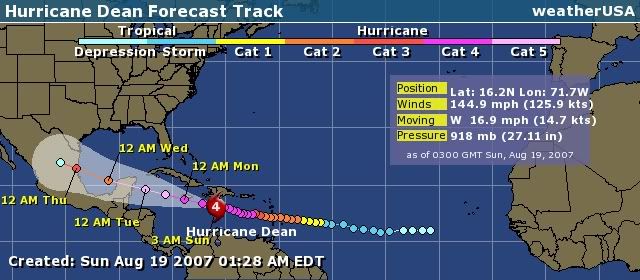


Comment